
Nine Mile Pond: Reflections of Wilbraham’s Past
- Jan 29
- 6 min read
Updated: Apr 29
Nine Mile Pond, lying quietly along Boston Road in Wilbraham, is far older than the town itself. Its story begins at the end of the last Ice Age, roughly 12,000 to 15,000 years ago, when massive continental glaciers still covered New England. As the climate warmed, the ice did not retreat evenly. Great blocks of glacial ice broke free, became buried beneath layers of sand and gravel deposited by rushing meltwater, and slowly melted in place. When the ice vanished, it left behind deep depressions known as kettle holes. Groundwater and surface water filled one such hollow, forming what is now Nine Mile Pond, a classic glacial kettle pond.

Wilbraham sits along the eastern edge of the Connecticut River Valley, an area shaped dramatically by glacial action. Thick deposits of sand, gravel, and till were left behind as the ice retreated northward, creating uneven terrain dotted with ponds, wetlands, and cedar swamps. Nine Mile Pond and nearby Spec Pond are enduring reminders of that prehistoric landscape, their clear waters fed by springs and groundwater moving through ancient glacial soils.
Long before Wilbraham had a name, these waters were known to the region’s Native people as Manchonis. Early records spell the name in many forms, Manchonis, Machonis, Massaconus, and Monchonis, but all refer to the same pondy and swampy region around Nine Mile and Spec Ponds and the surrounding cedar swamps. The name extended even to the nearby hills, which appeared in early documents as the “Manchonis Mountains.”

The word Manchonis, drawn from the Algonquian language of the Nipmuc people, was not poetic but practical. It described a fishing place, a reliable body of water where fish could be taken season after season. To the Nipmuc, place names were living records of use and memory rather than markers of ownership. These glacial ponds supported fish, waterfowl, small game, and edible plants, making Manchonis part of a broader seasonal landscape connected by Native travel routes linking the Connecticut River Valley with the uplands to the east. Nearby waters were also known as Wal-a-mu-sa, another Native name applied to both Nine Mile and Spectacle Ponds in North Wilbraham.
English settlers arrived in the seventeenth century to find these waters much as Native people had known them, quiet, productive, and dependable. Springfield was established in 1636 as Agawam Plantation under William Pynchon and renamed Springfield in 1641 after Pynchon’s hometown in Essex, England. As the settlement grew, colonists followed an existing Native path eastward to the Massachusetts Bay Colony. This route became known as the Bay Path and later the Boston Post Road. That ancient road passed between Nine Mile Pond and Spec Pond, a course it still follows today.
While the pond itself is prehistoric, its English name is colonial. The transition from Manchonis to Nine Mile Pond most likely occurred in 1729, when Lieutenant Roger Newbury, an early eighteenth-century surveyor, was hired by the proprietors of the Springfield Eastern Outward Commons to measure, divide, and mark the common lands east of Springfield. Newbury’s work transformed abstract land descriptions into physical boundaries and fixed place names on the landscape. Distance-based names were common in this period, and Nine Mile Pond was named for its approximate distance, nine miles, from the early Springfield meetinghouse on the Connecticut River. Nearby landmarks followed the same naming pattern: Two Mile, Four Mile, and Five Mile Ponds in Springfield; Eight-Mile Gutter; and Eleven Mile Brook, later known as Twelve Mile Brook, both locations in Wilbraham.
Nine Mile Pond has also experienced tragedy. On April 29, 1799, one of the most devastating accidents in Wilbraham’s history occurred when six young people drowned in a sailboat accident on the pond. Within two days, all but one, a sixteen-year-old girl, were recovered. Desperate efforts were made to find her body, including firing a cannon in hopes the percussion would force it to the surface and digging a trench to Eight-Mile Gutter in an attempt to drain the pond. The trench lowered the water level by only about one foot but permanently altered the pond’s drainage, sending its outlet toward the Chicopee River rather than the Mill River. The girl’s body was not found until sixteen days later, when two travelers walking along the Post Road noticed something drifting toward shore on a gentle breeze.
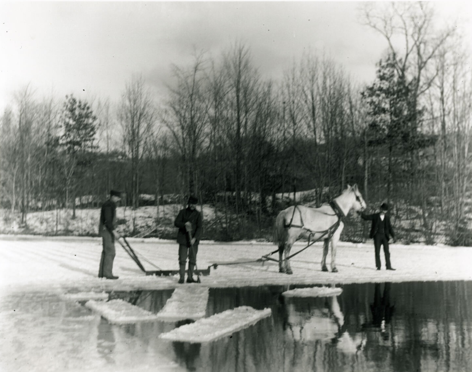
By the early nineteenth century, Nine Mile Pond became part of New England’s growing ice-harvesting industry. Each winter, when the ice grew thick enough, men cut the frozen surface into blocks and hauled them by horse and sled to icehouses along the shore. Stored under sawdust, the ice lasted through the summer months, supplying homes and businesses before mechanical refrigeration existed. This seasonal work, most active from the 1820s through the mid-1800s, provided extra income for local residents.
Another fatal accident occurred on July 27, 1911, during the waning years of the ice trade. A horse owned by Fred Metcalf drowned when it stepped into the pond for a drink while hitched to a wagon heavily loaded with ice. The weight of the load pushed the animal into deeper water, and it could not be saved.
In 1872, Nine Mile Pond became the subject of special Massachusetts legislation. An act approved on April 12 granted the Collins Paper Company the right to draw water from the pond for domestic and manufacturing purposes. At the time, water from the Chicopee River was too polluted by upstream mills for use in papermaking or drinking. Despite the legislation, there is no evidence that the company ever used Nine Mile Pond as a water source, relying instead on a nearby reservoir west of the mill.
By the late nineteenth century, Nine Mile Pond had evolved into a place of both labor and leisure. In 1894, the Springfield Bicycle Club constructed a clubhouse on the pond’s east side, signaling its growing role as a recreational destination. In the early twentieth century, the organization adopted the name Manchonis Club, preserving the pond’s original Native name. That chapter came to a dramatic close on October 15, 1935, when a spectacular fire of undetermined origin destroyed the two-story clubhouse, ending one of the area’s oldest recreational organizations.

The surrounding landscape reflected the pond’s layered history as well. West of the water stood the Bliss family farm, later known as Manchonis Farm, a name that echoed the pond’s earlier identity and carried its history forward.
That same year, Wilbraham witnessed an unusual sight on the pond. Marshall Lane, proprietor of the nearby Lakeview Inn, obtained a license to operate a small passenger steamboat called the Lakeview. Powered by a vertical steam boiler and capable of carrying up to twenty-five passengers, the boat offered leisurely rides across the pond’s calm surface. Steam drifting over the water must have been an impressive sight, but the venture lasted only a season or two. Managing both the inn and the steamboat proved too demanding, and the vessel was eventually sold.

The inn itself survived in different forms. In the early to mid-twentieth century, the property became known as the Auto Inn, reflecting the rise of automobile travel along Boston Road. By the 1940s and 1950s, it was widely known as Sullivan’s Auto Inn, a tavern and social gathering place where beachgoers crossed the road from Nine Mile Pond for food and drink. The original building was torn down around 1965, ending a chapter remembered fondly by many locals.


Development around the pond began in earnest in the early twentieth century as agriculture declined. In 1909, Herbert A. Northrop of Palmer purchased a peninsula on the eastern shore known as “the Island,” now called Bungalow Point. He laid out lots for summer cottages, and by 1913, about ten bungalows stood there, rented seasonally from May through mid-October. Soon afterward, similar cottages were built along the west shore by Clara Towne. Permanent residential development began around 1920.

In the early 1940s, the Lakeside Inn was built at 2589 Boston Road, serving for decades as a popular restaurant, lodging house, and entertainment venue overlooking Nine Mile Pond. By the 1950s, the Waters Edge on the pond’s northeast side had also become a local favorite, offering ten flavors of Sealtest ice cream and a private beach for swimming and sunbathing, though visitors were advised that swimming was at their own risk.


In 1952, Nine Mile Pond remained closely tied to the life of the Wilbraham community. Just two days after the town acquired its first ambulance, firefighters were called to the pond on August 21 to aid a four-year-old girl who had nearly drowned. Using a resuscitator donated by the Wilbraham Lions Club, responders were able to revive her at the scene. She later made a full recovery, a quiet but powerful reminder that this ancient pond continues to play a living role in the town’s unfolding story.
From glacial ice to Native fishing grounds, from colonial travel routes to ice harvesting, recreation, tragedy, and growth, Nine Mile Pond has remained a constant presence. Its waters reflect not just the sky above, but thousands of years of human memory layered upon a landscape shaped by ice.


Comments